| Newton Burgoland, Leicestershire - 2 March 2006 |
| A 6½ mile walk
along the canal and across fields and organised by Peter and
Talbert. 17 members attended, including for the first time Kevin
Glover, a long time Emgas Finance employee. Footpath sign on left across from the pub car park. At the bottom of Nethercote, turn left to Corner Farm where a public footpath sign will be found on the right. Pass through the metal gate where a well-used footpath leads to a stream. Follow the field perimeter path to the right over Swepstone fields to reach a stile and a farm track. Climb the stile opposite then cross a short field to a hedge and marker post. Turn left keeping a hedge close to your right and from here a path is easy to follow. A stile on the right needs to be climbed then with the hedge to your left continue to a farm road. Turn left, then in 100 yards turn right onto a track that is unsuitable for motors and skirt alongside a wood to the right to a public footpath sign on the right. Keeping a hedge close to your left once again walk ahead on the field perimeter path to a hedge gap. Continue ahead now following a line of stiles to eventually reach a track that leads to the road. Turn left and walk through Snarestone village passing the endowed school on the right to the Globe Inn. At the right of the pub car park, a path leads down to the tow path of the Ashby canal and immediately to the right is the entrance to Snarestone tunnel. Walk away from the tunnel entrance along the secluded grassy tow path. Pass beneath bridge 59 and continue to bridge 53 to leave the canal near the village of Shackerstone. Walk along the road to the left for 200 yards, and then turn left at the sign for Shackerstone Station to join a surfaced farm road. Continue along this farm road for ¼ mile to reach a public footpath sign on the right. An obvious field path well-waymarked leads to Fields Farm where a track is then joined. Continue along the track for ½ mile to eventually reach a gate and emerge onto a road. Walk along the road into the village of Newton Burgoland, to a road junction and turn left. This leads to the Belper Arms on the right. |
| Home Page |

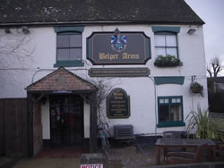 We started at the oldest pub in Leicestershire (circa 1290),
the Belper Arms in Newton Burgoland which is near Barton in the
Beans, Odstone, Shackerstone and Norton-Juxta-Twycross amongst
several other made up place names.
We started at the oldest pub in Leicestershire (circa 1290),
the Belper Arms in Newton Burgoland which is near Barton in the
Beans, Odstone, Shackerstone and Norton-Juxta-Twycross amongst
several other made up place names.